United States · Lost Towns
They burned, flooded, disappeared, or became too dangerous to call home.
6 American Towns You Can't Visit Anymore

Some towns slowly disappear.
These didn't.
Across America, entire communities have been emptied by underground fires, toxic contamination, reservoirs, industrial disasters and government projects.
Homes disappeared. Businesses closed. Roads ended. Families relocated. And in some cases, almost nothing remains of the community that once existed there.
These are six American towns you can't experience the way people once did — and the stories of what happened to them.
A note before we begin: “can't visit anymore” means the towns as they once existed. Some of these places are now parks or historic sites you can legally see. Others are private, contaminated or unstable. Each chapter explains what remains and what access, if any, is allowed. Please never enter restricted or hazardous areas.
Chapter 1
How a Town Disappears
Six ways a town can end
- 1. Centralia, Pennsylvania
- 2. Picher, Oklahoma
- 3. Times Beach, Missouri
- 4. Gilman, Colorado
- 5. St. Thomas, Nevada
- 6. Hanford, Washington
Chapter 2
Centralia, Pennsylvania — The Town Burning From Below

🔥 Cause: underground coal mine fire
Centralia was a small borough in Pennsylvania's anthracite coal region, with churches, stores, bars and a little over a thousand residents at the 1980 census. Beneath it lay a maze of abandoned coal workings.
The moment everything changed
In 1962 a fire began near the town and reached a coal seam. It spread through the old mine tunnels under the community, where it could not be reached or put out. Over the next two decades, residents dealt with carbon monoxide and other gases seeping into basements, and ground that was heating and sinking.
On Valentine's Day 1981, a 12-year-old boy fell into a hole that suddenly opened in his grandmother's backyard. He was pulled out by his cousin. The near-tragedy made national news and changed how the rest of the country saw Centralia's danger.
What happened to the people?
In 1983 Congress approved about $42 million to relocate residents. Most accepted buyouts and moved to nearby towns, and their houses were demolished. The town was not of one mind: some families refused to leave. Pennsylvania used eminent domain to take the remaining properties in 1992, and the U.S. Postal Service later retired Centralia's ZIP code. A 2013 legal settlement allowed the last handful of residents to stay in their homes for the rest of their lives.
The Graffiti Highway
A cracked, abandoned stretch of the old Route 61 near town was closed after the fire damaged it. Over the years visitors covered it with spray paint, and the “Graffiti Highway” became one of the best-known images of Centralia. In 2020 the private owner of the land had it covered with dirt, and it is no longer a place to visit.

What remains today?
A street grid with almost no houses, a few remaining homes, and churches and cemeteries that are still cared for. The fire is still burning underground.
Centralia, 2003

The fire beneath, 2006
Chapter 3
Picher, Oklahoma — The Town Poisoned by Its Own Mines

☣️ Cause: lead and zinc mining contamination
Picher grew up in the early 1900s in the Tri-State Mining District, where Oklahoma, Kansas and Missouri meet. Its mines produced huge amounts of lead and zinc, much of it during the World Wars, and at its peak the town was home to many thousands of people.
Mining left behind something the town could see from every direction: chat, the crushed waste rock left after the ore was removed. The piles grew so large that they looked like pale gray hills around the town. Children played on them. Some people used the material for driveways and fill.
The moment everything changed
When mining ended, contaminated water began flowing out of the flooded mines into Tar Creek, and heavy metals were found in soil and dust. In 1983 the area was added to the EPA's national priority list as part of the Tar Creek Superfund Site. Later testing found elevated lead levels in the blood of many local children, which made the danger impossible to ignore.
What happened to the people?
Families were offered state and federal buyouts, and most moved away in the mid-2000s. Then, on May 10, 2008, while the town was already being emptied, an EF4 tornado tore through Picher, killing six people and destroying much of what was left. The city government stopped operating in 2009.
Abandoned homes in Picher

The chat piles that surrounded them
What remains today?
Empty lots, some ruined buildings, and chat piles that are gradually being removed as part of the cleanup. Highway 69 still runs through the former town.
Chapter 4
Times Beach, Missouri — The Town Contaminated With Dioxin

☣️ Cause: dioxin contamination
Times Beach began in 1925 as a riverside resort along the Meramec River, promoted by a St. Louis newspaper. It grew into a small working town along Route 66 with about 2,000 residents. Many of its streets were dirt.
The moment everything changed
In the early 1970s the town paid a waste hauler to spray oil on its dusty roads. Some of that oil had been mixed with waste containing dioxin, a highly toxic chemical. Tests in late 1982 confirmed dangerous levels in the soil. Almost at the same time, in December 1982, the Meramec River flooded the town, spreading fear that the contamination was being carried everywhere.
What happened to the people?
In early 1983 the federal government announced it would buy out the entire town. Residents were permanently relocated, the town was disincorporated, and its buildings were demolished. The contaminated soil was later burned in an incinerator built on the site, and the area was cleaned up.
An unexpected ending
The site of Times Beach did not stay empty. It became Route 66 State Park, which opened in 1999. The visitor center is housed in an old roadhouse from the 1930s and tells the story of Route 66 and the town that was here.
The roadhouse that survived
Route 66 State Park today

What remains today?
Very little of the town itself: the land is now open fields, trails and river bottom. The community is gone, but its story is told on the spot.
Chapter 5
Gilman, Colorado — The Mining Town Left on the Mountainside

⛏️ Cause: mine closure and environmental contamination
Gilman was a company town built high on a cliff above the Eagle River, beside the Eagle Mine, which produced zinc, lead, silver and copper for about a century. Workers and their families lived right next to the mine and mill, with a school, a store and homes stacked on the mountainside.
The moment everything changed
The mine closed in the early 1980s. The town was abandoned in 1984 and has stood empty ever since. Mining waste had contaminated the soil and the Eagle River below, and the Eagle Mine area was added to the EPA's national priority list for Superfund cleanup.
What happened to the people?
Because Gilman was a company town, residents didn't own the land. When the mine and the company left, the families left too, moving to Minturn, Red Cliff and other nearby towns.
What remains today?
A surprising amount: houses, the school and the mine buildings are still standing, because no one bought out and demolished a town full of homeowners here. The whole site has been privately owned since it was abandoned, so it was simply closed off and left.
Chapter 6
St. Thomas, Nevada — The Town Swallowed by Lake Mead
🌊 Cause: reservoir construction
St. Thomas was founded in 1865 by Mormon settlers on the Muddy River, near where it met the Virgin River. It grew into a farming town with a school, stores and a stop on a road through the desert.
The moment everything changed
Building Hoover Dam in the 1930s created Lake Mead. As the water rose up the valley, the federal government bought out the land in St. Thomas. According to the National Park Service, the last resident, Hugh Lord, left in 1938, rowing away from his house as the water reached it.
What happened to the people?
Families moved to Overton, Logandale and other towns nearby. Some reburied relatives from the town cemetery on higher ground before the water came.
The town that came back
For decades St. Thomas sat underwater. As drought lowered Lake Mead, the town reappeared: concrete foundations, steps, cisterns and the lines of old streets are now exposed in the desert, far from the shore.
Then: leaving St. Thomas, 1930s

Now: foundations back on dry land

Chapter 7
Hanford, Washington — The Town Taken for the Atomic Age

☢️ Cause: government exclusion
Hanford and its neighbor White Bluffs were farming towns on the Columbia River in south-central Washington, surrounded by orchards and irrigated fields.
The moment everything changed
In early 1943, the U.S. government chose the area for a secret wartime project: producing plutonium for the Manhattan Project. Residents were told to leave. Their land was taken, and the towns were closed off inside what became the Hanford Site.
What happened to the people?
Families had only weeks to move out, many before they knew what the land would be used for. Hundreds of residents across Hanford and White Bluffs lost homes, farms and orchards. Many felt the government paid them too little for their land, and some went to court over it. Descendants have kept the towns' memory alive through reunions and oral histories.
What remains today?
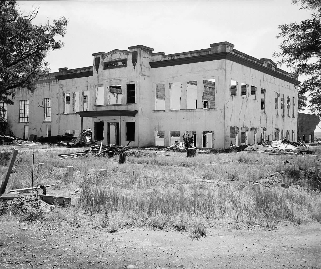
Almost nothing. Most buildings were torn down. The shell of Hanford High School and the old White Bluffs bank still stand inside the site.
Hanford High School, before 1943
The same school, empty, in 1954
A town doesn't have to survive on a map to leave a story behind.
Centralia still burns underground. Picher still carries the scars of mining. Times Beach became a park. Gilman's buildings remain empty above the Eagle River. St. Thomas disappeared beneath a reservoir — and eventually emerged again. Hanford gave way to the atomic age.
The people moved on.
But the places they called home haven't completely disappeared from history.
Sources & Further Reading
- Centralia Mine Fire — Pennsylvania Department of Environmental Protection
- Tar Creek (Ottawa County) Superfund Site — U.S. EPA
- Times Beach Superfund Site — U.S. EPA
- Route 66 State Park — Missouri State Parks
- Eagle Mine Superfund Site — U.S. EPA
- St. Thomas — Lake Mead National Recreation Area, National Park Service
- Manhattan Project National Historical Park: Hanford — National Park Service
- Hanford Site history — U.S. Department of Energy
Know someone who remembers?